Chalco, whose name comes from the Nahuatl, comes from shenmuesong "edge of lake" and co "place", meaning "on the edge of the lake." The meaning of this word has been discutida.
The glyph is surrounded by four small jade beads, the center, a flat mirror of jade that was much appreciated by considering it Chalca tool for the wise, a ring, which corresponds to the edge of a concave mirror quartz yellow is partially covered with the flat mirror of jade, a red concave mirror, which the bank is only like a crown on it are the two mirrors and a flower ring consisting of 20 petals that mean integration duality, the unity of male and female forces in the family and neighborhood.
Historical Review
The first group to reach the region of Chalco-Amaquemecan was "the acxotecas" which states Chimalpahin coming from Tula, the famous and ancient homeland of the Toltecs, and was the first town to be known as Chalco, had a government of nobles. The second group to arrive was that of Mihuaques that lacked president and took the noble lineage of acxotecas. 2 / about 1160 AD come from Chichimecs Teotenanco Toluca Valley, past Tlahuac 3 /. Around the lake there were other groups, cuixocas including, temimilolcas and ihuipanecas the congregation which formed a tribal with Chalca. In 1258, Xico reach the next Chichimecs Chalca already had 18 years of inhabiting the region of the lagoon with a reputation for great soothsayers and sorcerers because of which the surname was Chichimecs atempanecas (those living near the water).4 / Also, came the nonohualcas teotilixcas tlacochalcas Tlalmanalco who settled by the Tecuanipan, who settled in the direction of Amecameca, some people also came from Panuco panohuayas who constituted the fourth quarter of the manor, "each group who settled aro

und the Lake took a proper name but retained the Chalco in addition, all these formed a congregation of tribes with Chalco. Being so from this time joined Amaquemecan Chalco region, where Confederates were several groups with different lifestyles who being also different from each other ethnically and linguistically, they manage to make Chalco productive agricultural region from the century XIV, enjoying his corn a great reputation.
Towards 1354 the region was known for Tzacualtitlán-Tenanco Amaquemecan-Chalco. 5 / In "1363 the territory was divided into local estates, which were Iztlacozuahcan-Amaquemecan, Chalco-Amaquemecan Tzacualtitlán-Tenanco-Amaquemecan and Tecuanipan-Amaquemecan. 6 / "In 1410 the territory of a state almost Confederate Chalca, consisted of four domains: Acxotlan-Chalco, Tlalmanalco-Amaquemecan Tenanco-Xochimilco-Chimalhuacan Tepopollan and, being the Leader Acxotlan-Chalco. 7 /
The Mexica arrival at Tenochtitlan no land to cultivate and provide Chalco corn which enjoyed great fame for 1465 Chalco province becomes a tax and collection centers were: Chalco, being Tlalmanalco head, Quauxumulco, Tepuztlán, Malinaltepec, Temilco and Xocoyaltepec, these taxes were produced by the floating gardens of the lake. The war as a means of expansion and conquest becomes common, we shall mention only one of many:in 1376 begins the "flower war" that lasts 8 years and is between Mexico and Chalco, in this war when apprehended Mexica nobles to the left Chalca free and so did people Chalca only died in battle and is due to this long struggle for survival and defense of the territory that the Chalco region fails Amecameca splendor of Texcoco and Tenochtitlán.
Two versions of the arrival of Hernan Cortes in the region of Chalco-Amaquemecan, one says that the Chalca to be aware of the presence of Cortes in Tlaxcala and Cholula, await in the step of volcanoes and bring him gifts of gold, the other says that the Chalca were to receive Cortes to Texmelucan and presented him jewels, valuable stones, bracelets, blankets, feathers meals including 8 /. Cortes in his 2nd letter relationship tells us that started from a village Amecameca that is the province of Chalco, and on the road receives ambassadors of Montezuma asking you to return or that the order of Montezuma wait to receive it. Cortes spent two days in Amecameca where he treats him good food, gold and slaves.
Meanwhile, in his book Clavijero Mexico's Ancient History tells us that "Cortes Ayotzingo Amecameca became a place that serves as places from the lowlands. Cacamac get to the Spanish in Ayotzingo, gives them supplies and offered the city of Texcoco to turn away.Ixtlixóchitl along with the Spanish helped to defend Chalca people of Xochimilco and Tlahuac, were once allies of the Spanish, Cortes Chalca seeking protection against the constant threat of the Mexica, thus forming a coalition of different tribes against the Aztecs, with the defeat of the Mexica Chalca again dominate their territory being committed and available to the Spanish, thus being the Chalca forced to participate in expeditions. The colony is started from the moment that is the distribution of land among the conquerors. "Chalco in 1533 becomes a real province of the hearing decision," 9 / was of great importance as an area producing corn, wheat, barley, straw, firewood, charcoal, fruits, vegetables, building materials such as wood, volcanic rock and stone and its piers and Chalco Aytozingo that were favored by the heavy traffic and close to Mexico City. In addition comes the Commandery, Cortes himself assigned to the province of Chalco, Nuno de Guzman in 1520 seized the province and their taxes.Tributes have also been assigned to the Dominican order to build a monastery and the tributes of corn were appointed to the Marquis.
With the decline of the Commandery in 1530 emerged in 1563 the district and the district comes in Chalco whose boundaries are constantly moving between Tlayacapan and Tlalmanalco. The township was prolonged in Chalco and elsewhere throughout the colonial period, the large estate of Chalco had its origins in the royal grants awarded between 1560 and 1642, the first land grant was awarded in 1565 to Juan Bautista Avendano and Antón Méndez in 1614 and 1641 and Hernando de Aguilar, Alfonso Núñez Casillas and Diego Ruiz Lozano, asked permission to bring in beef cows and used for producing milk, cheese, butter, etc.. Arise simultaneously primogeniture and chiefdoms, in terms of primogeniture in the province of Chalco, the most important was that of Don Miguel Saenz de Sicilia y Soria, by a decree issued in Madrid on May 4, 1774.
Lake Chalco had a major influence as Chalco in the sixteenth century was a lake port in four docks where the dock trajineras carrying vegetables and seeds to Mexico City. During the nineteenth century, the most salient are:at the consummation of Independence, the Constitution was promulgated in 1824 formed the Free and Sovereign State of Mexico with the district of Acapulco, Cuernavaca, Huejutla, Mexico, Apaxco, Toluca, Tula and Tulancingo, both parties Chalco, Coyoacan, Cuautitlan , Ecatepec, Mexicaltzingo, Mexico, Tacuba, Teotihuacan, Texcoco, Xochimilco and Zumpango. In 1861, the county seat is named village and imposed the surname "Diaz Covarrubias" in (a tribute to Juan Diaz Covarrubias medical student and killed by Leonardo Mark on April 11, 1859). Chalco was also the scene of the encounter of Maximilian and Empress Carlota Amalia who comes to receive his return from Yucatan.
"Stresses in the State of Mexico, the indigenous peasant rebellion by Julio Lopez Chavez made that although it was very short (December 1867-1868), had great significance to regional and national level, which is why some authors as Gaston Garcia Cantu, Manuel Diaz Ramirez, John Hart and others have said that this move was a precursor of the Zapatista movement (almost 40 years earlier). Julio Lopez Chavez begins his agrarian movement in favor of the division of estates among the Indians exploited, since for him the Indians were the owners of the lands, this movement started in San Francisco Acuautla, Coatepec and St. Vincent Chicoloapan, also was shot on 9 July 1868 inside the Ray school and Socialism. " 10 /
During the Porfiriato that a major economic activity, as the meeting point for traders from different places, the continuous water communication with their canoes and steamboats, the industry achieves greater development, and farms reached its peak since its beginnings were in the late sixteenth and early seventeenth centuries.Within the estate the most prominent are those of Xico, the Company, the Moral, among others, also in 1895 installed the Regional Agricultural School which had not existed, and in the same year is dried Lake Chalco , the few fishermen who disappeared was later these lands were used as farmland. In 1890 the president of Mexico, General Porfirio Díaz laid the foundation stone for the first City Hall and in 1893 was opened by the same agent.
As the revolutionary movement of 1910, the municipality of Chalco had some clashes between Zapatistas and Carranza They take Ayotzingo church, the burn twice, shoot several men, outraged women, destroy the Zapatistas Chalco parish records, part of the church and several houses.
By 1979 on the grounds of Lake Chalco dried begins human settlement Latin America's largest known as Chalco Valley with more than 500,000 in the first stage. That's why the county seat is elevated to city status in March 1989 after 30 November 1994 the inhabitants of Chalco Valley are fighting for their separation in search of an identity and a better life , for it was established 122 township called Valle de Chalco Solidaridad.
Important People
Chichipepon. Poeta litigant belongs to the nobility Chalco, in one of his poems give us an idea of the history of Chalco (1486 -). Domingo Francisco de San Antón Chimalpahin Quauhtlehuanitzin Stump (1579-1660). Chronicler and historian, author of works original relations of Chalco-Amaquemecan and the Journal. Plotinus C. Rhodakanaty. Originally from Athens Greece, founded in Chalco's "School of the Ray and Socialism" or "Escuela Libre de Chalco" (-1828). Julio Lopez Chavez. Chalco Organized in the "social club" and starts in 1868 the agrarian movement (-1868). Quezada Vicente Mendiola. Architect and artist, wrote several works which we can mention the Capital History of Toluca, catalog Religious Monuments of the State of Hidalgo, an artist known for his watercolors and oil paintings (1900 -- 1986). Job Martinez Morales. Bachelor of Arts Education, Music and Folklore, as a pianist has performed chamber music and as a folklorist has participated in conferences and national forums (1954 -). Jose Castillo Hita.Surgeon with Master and Doctor of Reconstructive Plastic Surgery. He has done research on the healing of burns and reconstructive surgery of the hand (1928 -). Feliciano Perez Cardenas. Canon of the Basilica of Guadalupe conducted studies on the ruins of Xochimilco, was nominated for the bishopric of Chilapa but I do not accept ( 1815-1878). Antonio Repiso. Pastor of Xochimilco, founder of the Congregation of Handmaids of the Divine Shepherd, itinerant missionary lived 15 years in the Sierra Tarahumara (1856-1929). Leyte Angel Pacheco. chalqueño Distinguished journalist and researcher of ancient history Chalco.
2400 BC First Chalca sedentary.
1241 twelfth and thirteenth centuries AD, reaching the founding Chalco Chalco-Atenco. 1242 The totolimanecas settled in the valley of Toluca came to Atenco and Chalco introduced in the government of its leader Atonaltzin place after subjecting Chalca. 1242 The Chalca are forced to abandon their land. tlalmanalco-1266 The Chalco Chalco to occupy from T

lalmanalco. 1300 Under the administration of the estate was consolidated Atonazaltin Chalco Amecameca. 1304 he founded the third quarter of this city (Chalco-Atenco). 1324 occurred Xochiyaotl conquest and maturity (War of the flower) made by Chalco. 1354-1363 Chalca The rule of the government under the Hueconti was divided into 4 parts: Iztlacozahuacan Amequemecan, Chalco Amequemecan, Tzacualtitlán Tenanco Amequemecan and Tecuanipan Amequemecan. There were 1376 another war in Chalco-Atenco that lasted 8 years. 1386 In this year the Aztecs began their conquest of the Otomi of Matlalcingo in the Central Valley, Cuajimalpa in the Sierra de Monte Alto and Las Cruces. The Chalca Matlazincas dominated the South Central Valleys.The Otomi of 1410 supported by the Mexica Xiquipilco officials Chalca reinstalled in their old positions. Chalca As important work helped the termination of the agreement of Chapultepec, which was completed in the year 1466. Chalco 1474 artisans participated in fashioning the Sun Stone (also known as the Aztec Calendar). 1519 Hernán Cortés Tlalmanalco goes through, the estate village of Chalco, continuing by Ayotzingo, this being the largest port in the lake of Chalco which served as a bridge to the great Tenochtitlan, for transporting goods traveling from the Gulf of Mexico. 1520 Chalca join Hernan Cortes after the defeat of the sad night. 1530 built the Mayor of Chalco. 1542 After slavery persisted in New Spain, was the year it was abolished, but at that time the division of Chalco 4300 amounted workers. 1550-1564 At the time of Viceroy Luis de Velasco ordered the construction of fences to separate farmland from the fields for to livestock.However, the area has managed to maintain their production of grain. The maize was plentiful in Chalco, whose grounds were for its fertility the richest agricultural area. XVIIII The XVII and estates are built in Chalco. Chalco eighteenth century was considered as the main producer of maize, its fertile agricultural land. It arose largest dairy catchment area, being the pioneers in the production. Not only was important in the agricultural aspect but also in industry, since in this century textile factory was established in Miraflores. In Chalco's annual production reached 7% of production across the country. 1816 After the independence movement started around the year 1816, on 16 February a group attacked Chalco, defeating the regime of this population. 1824 31 January rising to the rank of Chalco municipality. 1861 Legislature of the State of Mexico by decree No.45 November 14 raised to the rank of the Headboard Villa District and as the name puts "Diaz Covarrubias" in honor of Juan Diaz Covarrubias, one of the practitioners of medicine who was shot in Tacubaya. Chalco witnessed the 1865 meeting Maximilian and Empress Carlota, who returns from Yucatan. 1868 arise in the State of Mexico, the first workers' associations, this being the "union of Miraflores Weavers and mutual societies factory" San ldelfonso "and" The Hive. "1860 -1870 develops the first strike in Miraflores, being previous to the Rio Blanco and Cananea. 1868 Given the abuses of the planters developed one of the largest peasant struggles historic significance, which was directed by Julio Lopez, who is get up in arms against the Republican government in Chalco and requesting the allocation of farms to the Indians. 1890 President of Mexico, General Porfirio Díaz, March 9, laid the foundation stone will be built where the city hall was inaugurated by him in 1895. 1895 start acting Regional Agricultural School of Chalco.1895 in October under the direction of Spanish Iñigo Noriega work began for the defecation of Lake Chalco leaving this place fertile land that produced good quality and quantity of corn and beets. 1911 For the Zapatistas were some of the bloodiest clashes this time in the town of Chalco. 1915 In the throes of revolution Chalco Square was the scene of bloody clashes between Carranza and Zapata. An indelible mark among the Catholics of Chalco was the looting and burning of the church, by the Carranza taken as a barracks. 1917 Chalco is called Judicial District and rentiers. 1950 The excessive concentration of industries and population in Mexico City, caused them to make industries in the neighboring towns of Chalco, to achieve a population balance. 1954 on the mountainous Ayotzingo of the population in the municipality of Chalco, a group of Cubans led by Fidel Castro and that included in Dr.Ernesto "Che" Guevara, was his training and target practice in preparation for the Granma expedition that began with the Cuban revolution, building supply center in the town of Chalco. 1970 demolished the old city hall to build the current which is inaugurated in January 1973. 1979 Highlights On the grounds of Lake Chalco, human settlement begins Latin America's largest known as Valle de Chalco, with over 500,000 inhabitants. 1988 May 12, Mr. Carlos Salinas de Gortari campaigned for the Presidency of the Republic, established the social challenge against marginalization and extreme poverty, introducing basic services to the Valley of Chalco and proposing the creation of a National Solidarity Program. 1989 The March 28 for Decree No. 14 is elevated to city, the town of Chalco. 1990 On May 7, arrives to Valle de Chalco, Pope John Paul II, this region was encouraging world and sadly coincides with the publication by all the media marginalization in which the inhabitants lived .1989-1993 was established large industries are encouraged Stamping and farming activities in the municipality. 1994 Starting November 30, establishing the municipality does not. 122 of the State of Mexico, known as Valle de Chalco Solidaridad, in order to provide better living conditions for inhabitants of that region for all known, allowing further that the funds of social benefit is better control.
Location
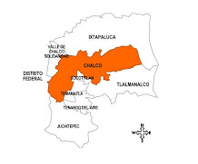
Chalco municipality is located east of the State of Mexico, between latitudes 19 ° 09 '20 "north elevation and 90 ° 58' 17" west longitude. The average latitude of the municipality is of 2,550 meters above sea level, is the county seat town of Chalco. Bordered on the north by the municipality of Ixtapaluca, south with the municipalities of Cocotitlan, Temamatla, Tenango Juchitepec Air and east with the municipality of Tlalmanalco the west by the Federal District and the municipality of Valle de Chalco Solidaridad.
It has a total area of 234.72 km, considering the surface segregation by the formation of 122 municipal Valle de Chalco Solidaridad.11
The municipality of Chalco orography has a terrain relief with three characteristics: accidental area 33% of the territory is located south of the town and the hills Tlapipi, the papaya, Pedregal de Teja, Coleto and Ixtlaltetlac. Semiplana Zone represents 20% of the area to the west Cuauhtlalpan St. Martin and St. Mary Huexoculco, giving rise to the formation of small intermontane valleys, the plains is taking place west of town. Hydrography within the municipality are two rivers To the north of the river entity of the Company, and south the river or Ameca Asuncion, note that both streams have a high degree stormwater pollution, serving as drainage for the evacuation of solid and liquid waste, garbage home, causing environmental degradation. There is another aspect of hydraulic resources, because it has deep wells and streams as:"The Cedral", "Drawer", "El Potrero", "Telolo", "Palo Hueco" and "Santo Domingo." The climate of the municipality according to the classification of Koeppen's Cwbg temperate subhumid with summer long, rain winter below 95%, isothermal, and the highest temperature occurs before the summer solstice. In the elevated region to the east, the weather is C (E) wg, semi-cold-humid, with precipitation less than 5% winter, summer is long, is isothermal and the temperature is highest before the summer solstice. The average annual temperature is 15.6 ° C in the summer the average maximum temperature reaches 31 ° C and average minimum is 8.2 ° C in winter. The monthly temperature is highest in April, May, June, July and August are the mean minimum in December, January and February to determine the existence of some frost. Some low temperatures have been recorded in the summer on some days in July or August by the decrease in air humidity, whereas the day temperatures are high and at night cold winds are presented. The dry months are:January, February and March although some untimely rains in May, June, August and September which are abundant. major ecosystems in terms of vegetation on the flat part of the municipality is low although the roadsides of Cuautla and Mixquic trees exist, and in villages there is little vegetation in the upper canopy open, pine, cypress, pine, cedar, oak, willow, jacaranda, camphor, and thunder and bright colors in the middle and lower parts are the species pine: Moctezuma, Rudis and teocote. The fauna from the municipality is of wild rabbits, squirrels, weasels, skunks, lizards, snakes, rattlesnakes, mice, rats, rabbits, coyotes, some predators like the hawk , hawks and vultures. Characteristics and Land Use The region belongs to the Miocene-Pliocene period, the last of the Tertiary period which gave rise to the formation of the volcanic mountain range with the result that the town has igneous rocks;have also been formed which sedimentary rocks are formed by the drag of water and wind, which we can say that the soil is composed of Chalco by 70% of rocks covering the surface. The municipality has different soil types are determined by the weather or rocks and are as follows, Andosol, Cambisol, fluvisol, gleysols, Solonchak and Vertisol, soil is so diverse and productive to be very fertile but present problems for management because of its hardness.
Ethnic Groups

Within the township are as mixed groups, Totonac, Mazahua, Mazatec, Zapotec, Otomi, Nahua and Mixtec, this being the predominant. Being of 2,804 the number of people who speak an indigenous language in this entity. According to the results presented in the Second Census of Population and Housing in 2005, living in the township a total of 5.057 people who speak an indigenous language. Evolution Population The town has suffered in the past three decades a strong demographic impact that reverberated nationally, the process changed its growth pattern and population distribution and socio-economic relations, from the 70s began the migration stream, same are exacerbated in the next decade, due to its proximity to Mexico City and the propaganda that the ground here is getting cheaper, that even much of this land was invaded, becoming a magnet for poor migrants from throughout the Republic.This migration resulted in the creation in 1994 of the municipality of Valle de Chalco Solidaridad, which was creed from the municipality of Chalco. In the municipality of Chalco, a total of 106.450 inhabitants in 1990 and in 1995 this amounted to 175.521. It is important to note that by the year 2000, according to preliminary results of General Census of Population and Housing carried out by INEGI, for then existed in the town a total of 222.201 inhabitants, of which 109.161 are men and 113.040 are women, this represents 49% male and 51% female. According to the results presented in the Second Count of Population and Housing in 2005, the township has a total of 257.403 inhabitants.

Education
Within the municipality for basic education, there are 65 preschools, 78 primary, 48 secondary schools, 12 preparatory and technical education (CBTIS and CONALEP), school of arts and crafts and INEA. For the top level has the Normal Superior and a university campus built in which the degrees are offered in Accounting, Law, Computer Management and Psychology. In this way, the township has a total of 205 schools that are attended by 2.177 teachers. Furthermore, this entity has 98.057 inhabitants 8.499 literate and illiterate. The municipal health clinics are installed: IMSS, ISSSTE and ISEMYM and there are also private. As the municipality has a total of 22 public institutions for health care. Abasto The business has grown so much in recent years, so there is already commercial corridor located along the Boulevard Cuauhtemoc also the creation of two shopping malls. It has 15 delegations markets and colonies, the most important are two operating in the county seat.There is a swap meet in each of the 13 municipal offices, of which the oldest and most important, is what is installed on Friday in the main town, dating from the prehispanic period. There are bakeries, poultry, tortilla, butcher , egg outlets, groceries, stationery, shoe, clothes in general, pharmacies, furniture, miscellaneous, hardware stores and hardware stores. Sports are sports facilities such as Chalco Sports, Recreation Park "Alfredo del Mazo, the Municipal Gardens, Stadium "Joaquin Iracheta" the Club "Arreola" Pediment and Municipal. Housing The predominant material in the construction of housing in the borough are: cement, brick, brick or stone, but are some of adobe, the roofs are made of earthenware, asbestos sheet, cardboard and metal, the floors are concrete or firm ground, on a smaller scale wood or tile and housing units are single material. According to the 1995 count, in this entity are 35.343 houses , 35.336 of which are private and 7 are collective.It is noteworthy that in 2000, according to preliminary data from the General Census of Population and Housing, conducted by the INEGI, until then, there were 48.034 homes in the municipality in which on average 4.57 people live in each. From According to the results that I present the Second Census of Population and Housing in 2005, in the municipality have a total of 52.311 households out of which 48.863 are private. Public Service of the houses in this entity, 88% have piped water , 75% have drainage and 98% have electricity. the Media The media account with which the municipality are: the newspapers and magazines that are distributed as: El Universal, This, La Prensa, El Financiero, La Jornada, Excelsior, Novedades, Cheers, Hobby, Reforma daily coverage and some state and local magazines such as Proceso, Mexico Unknown, Arqueología Mexicana, Leisure, Buenhogar, Kena, Crafts and Music.TV channels received are those of TV Azteca (7 and 13), Televisa (2, 4, 5 and 9), Channel 11, Channel 22 and Channel 40, television programming does not reach the town Mexico State. Recently installed a cable system that covers part of the county seat, also has satellite TV systems .
CULTURAL AND TOURIST ATTRACTIONS
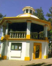
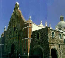
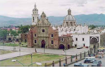
Landmarks Within the municipal find St. James Parish, the Franciscan convent dating from the sixteenth century, the Red House, the Town of the Ex-Hacienda de San Juan, the murals inside the mayor, city kiosk, and the Open Forum of Colonia Emiliano Zapata. In some populations that make up the municipality are as follows: La Candelaria Tlapala the front of the mausoleum built in the seventeenth century Church of the Candelaria. Cuautzingo San Gregorio, parish of St. Gregory the Great, the Assumption Chapel, Chapel of San Juanito, finance San Jose de Chalco "The Company", processing of clay (tabiqueros) built in the nineteenth century. Amalinalco St. Luke, St. Luke's church built in the eighteenth century is one of the few popular Baroque buildings in the State of Mexico. Iglesia San Mateo Tezoquipan Miraflores. Bridge Melchor Ocampo, exhacienda "Del Moral," formed the basis of some grants and purchase of plots of land from the Indians during the sixteenth century and first half of the seventeenth c

entury is installed textile factory "Miraflores".At first it was a farm, is then installed a textile factory in 1840 and the company was founded by Felipe Nery Miraflores and the brothers Martinez del Rio. Atlazalpan St. Paul, St. Paul's Church, when eighteenth-century building restored to its internal in 1982, facade pantheon "Reform", built in August 1906, ex-hacienda Axalco not know the date of construction. Ayotzingo Santa Catarina, Santa Catarina Martir Church Augustinian convent built in the mid sixteenth century Gothic house known by this name for its arched windows, ancient palms, the antiquity of these palms is unknown, a statue of Fray Martin de Valencia, facade of the mausoleum built in the twentieth century .
Museum "Archaeological Chalco, located on the top floor of the House of Culture Chimalpahin.
Parties, Dances and Traditions In the municipality of Chalco celebrate religious festivals and traditional employers below mention a timetable.Poblado La Candelaria Tlapala Date February 2 "La Candelaria" San Gregorio Cuauzingo March 12 San Gregorio Magno San Marcos Hixtoco 25 April "San Marcos" San Juan and San Pedro Tezompa June 24 "San Juan" San Pablo Atlazalpan 29 June "Saint Peter and Saint Paul" Chalco de Díaz Covarrubias (header) July 25, "Santiago Apostol" San Lorenzo Chimalpa 10 de Agosto "San Lorenzo Santa Maria Huexoculco August 15" The Assumption "Matthew Tezoquipan 21 September "San Mateo San Mateo Huitzilzingo September 21 San Mateo San Lucas Amalinalco October 18 San Lucas San Martin Cuautlalpan 11 November falls" San Martin Obispo San Martín Xico Nuevo 11 November "San Martin Caballero Santa Catarina November 25 Ayotzingo Santa Catarina Martir "Of the religious festivals celebrated in every community in the municipality include the carnival to be held in Santa Maria Huexoculco, San Marcos Huixtoco, Tezoquipan Miraflores San Mateo and Santa Catarina Ayotzingo passion Christ at Easter.Folk feasts From 16 to 31 July was conducted by the religious festival in honor of Santiago Apostle in the municipal and 24 to 26 November in the town of Santa Catarina Ayotzingo in honor of Santa Catarina Martir. Traditions For the party of All Saints and All Souls is customary to place an altar on which is offered to the dead the food that they liked. The Dance of the "shepherdesses" takes place Atlazalpan San Pablo, where they worship the lord of the month Tepalcingo March in San Juan and San Pedro Tezompa is performed on the day of San Juan in June but has been losing lately, also the dance of "chinelos" takes place in the town there are some extras including .
Cronología de los Presidentes Municipales
PRESIDENTE MUNICIPAL PERIODO
Antonio G. Espinosa 1919
Francisco Arechavala 1920
Adolfo Granados Rojas 1921
Manuel Alemán Ahedo 1922
Adolfo Granados Rojas 1923
Bernardino Ahedo Ortega 1924
Adolfo Granados Rojas 1925
Jesús Alvarez Martínez 1926
Baldomero S. Lara 1927
Jesús Alvarez Martínez 1928-1929
Rafael Iglesias Jurado 1930-1931
Loreto Vargas Vargas 1931
Jesús Alvarez Martínez 1932-1933
Adolfo Granados Rojas 1934-1935
Alberto Galarza de la Peña 1936-1937
Dionisio Pérez Hernández 1938-1939
Manuel Alemán Ahedo 1940-1941
Dionisio Pérez Hernández 1942-1943
Antonio Matamoros Oses 1944-1945
Daniel Moreno Castelán 1946-1948
Onésimo Cadena Rangel 1949-1951
Armando González Sánchez 1952
Dionisio Pérez Hernández (PMDL) 1952
Aquilino Hernández Ponce 1952-1954
Daniel Moreno Castelán 1955-1957
Santos Meza Garcés 1958-1960
Francisco Rodríguez Flores 1960-1960
José Carvaja García 1961-1963
Abundio Pérez Martínez 1964-1966
Bernardo Aragón Sánchez 1967-1969
Héctor Ximénez González 1970-1972
Hugo Barrera Paredes (PMDL) 1972
Héctor Ximénez González 1972-1972
Salomón Mondragón Gutiérrez 1973-1975
Santos Meza Garcés 1976-1978
Felipe Medina Santos 1979-1981
Adriel Horteales Maqueda (PMDL) 1981
Cliserio Hernández Ponce 1982-1984
José Gerardo de la Riva Pinal 1985-1987
Javier Segismundo Téllez Sánz 1988-1990
Jesús Robledo Madrid (PMDL) 1990-1990
Marco Antonio Tapia Sánchez 1991-1993
Felipe Medina Santos 1994-1994
Gonzalo Hernández Moreno (PMDL) 1994-1996
Martha Patricia Rivera Pérez 1997-2000
Eulalio Esparza Nieto 2000-2003
Jaime Espejel Lazcano 2003-2006
Vicente Alberto Onofre Vázquez 2006-2009
REFERENCES
Gibson, Charles, The Aztecs under Spanish rule, 1519-1810, Siglo XXI, twelfth edition, Mexico City 1994, 528 pp. Government of the State of Mexico. Collection of decrees, decree no. 19 Volume 22, decree no. 47 volume 23 and Decree no. 82. German Rodriguez, Oralia. Chalco. Monograph City, Mexico State Government / Municipal Writers Association Mexiquense / Mexiquense Institute of Culture, Toluca, Mexico, 1999 180 pp. H. Constitutional Ayuntamiento de Chalco 1997-2000, Bando Municipal de Chalco, Chalco, Mexico, 1998. National Institute of Statistics, Geography and Informatics. Census of Population and Housing 1995, Final Results, Basic Tabulados, Volume I, Ags. Mexico, 1996. Martínez, Raymundo. "San Martín Xico (Xico Nuevo), municipality of Chalco," In my village, its history and traditions ", coord. Margarita Loera Chavez, Library Outreach, INAH / Government of Mexico, Mexico City 1987, 321 pp. Román Piña Chan. The State of Mexico before the Conquest, UAEM, 3rd edition, Toluca, Mexico, 1987, 152 pp.---, The Chalco Region in ancient times, Directorate of Tourism, Government of Mexico, Toluca, Mexico, 1975, 23 pp. Romero de Terreros, Manuel, Ayotzingo, Directorate of colonial monuments INAH, Mexico City, 1957 , 335 pp. Schroeder, Susan, and the kingdoms of Chimalpahin Chalco Spanish version of Joaquin Francisco Zaballa Oman, College Mexiquense / H. Constitutional Ayuntamiento de Chalco 94-96, Mexico City 1994, 335 pp. Velasco, Luis Alonso, Geography and Statistics of the State of Mexico State Library Enciclopédica Mexico City 1980, 194 pp.
CREDITS
Coordinator: Antrop. German Oralia Reyes. Chalco municipal chronicler. Research and text. Contributors: Profra. Ma de la Luz Diaz Rojas Jose Antonio Garcia Medina Lic Prof. Alejandro Lopez Lopez Prof. Arturo Cordova Galicia Ms. Oliva Fernando Bojorges Mr. Buendia Reyna Calderon Ms. Guadalupe Melchor Diaz Ms. Rosa Elena Diaz Melchor Lino Martínez Rebollar.
Notes:
1. Government of Mexico. Municipal Monograph Chalco, Toluca, Mexico 1999. pp. 1. 2. Schroeder, Susan Chimalpahin Chalco and the kingdoms of "Colegio de Mexico, Mexico City 1994, pp. 85. 3. Pina Chan, Roman. "The State of Mexico before the conquest" UAEM Toluca, Mexico 1987, pp. 110. 4. Ibid pp. 14. 5. Ibid pp. 113. 6. Roman Piña Chan "Chalco Region in ancient times" Government of the State of Mexico Toluca, Mexico 1976, pp. 16. 7. Pina Chan Roman "The State of Mexico Before the Conquest" UAEM Toluca, Mexico, 1987 pp. 114. 8. Government of Mexico. Municipal Monograph Chalco, Mexico Toluca 1999, pp. 150. 9. Gibson, Charles. The Aztecs Under Spanish rule Mexico City 1519-1810 Siglo XXI twelfth edition 1994, pp. 370. 10. Government of Mexico. Municipal Monograph Chalco. Toluca, Mexico 1999, pp. 168. 11. INEGI. State of Mexico. Definitive results, basic tabulated. Volume I Census of Population and Housing 1995. 12.Government of Mexico. "Collection of Decrees" Decree No. 82 ". 13. Velasco, Alfonso Luis. "Geography and Statistics of the State of Mexico," Encyclopedia of the State Library of Mexico, Toluca Mexico 1980 pp. 77. 14. Government of Free and Sovereign State of Mexico "Collection of Decrees" Decree No. 47 Volume 23 pp. 481. 15. Government of Free and Sovereign State of Mexico "Collection of Decrees" Decree No. 19 volume 22 pp. 145. 16. Raymundo Martínez San Martín Xico (Xico Nuevo). "My Village: its history and traditions." Coord. Margaret Loera. Library Outreach Mexico, DF 1987 INAH Mexico State Government pp. 204. 17. Ibid. pp. 304. 18. Ibid. pp. 319. 19. Ibid. pp. 306. 20. Romero de Terreros, Manuel, "Ayotzingo. Address 1959 Colonial Monuments INAH Mexico pp. 57. 21. Velasco, Alfonso Luis. "Geography and Statistics of the State of Mexico" Encyclopaedic Library of Mexico State, Toluca, Mexico 1980 pp. 76. 22.Government of Free and Sovereign State of Mexico "Collection of Decrees" Decree No. 47 Art. 3rd Volume 23 pp. 481. 23. Bando Municipal, Chalco, Estado de Mexico, H. Ayuntamiento Constitucional 1997-2000. 24. Information collected by Mr. Hugo Flores Velasco, resident of Chalco and researcher and local historian .